One of my current projects is to create abstract photographs of my hometown of Niagara-on-the-Lake, Ontario, Canada. With abstract photographs, we try to reflect the mood or emotions or qualities of a place. Each Tuesday, I’ll present a new image from the project.
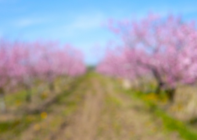
This is the moment we locals have been waiting for. After a long, cold winter the fruit trees are blossoming – peach trees above, as well as apricots, plums, and pears.
Niagara-on-the-Lake is one part of the Niagara Peninsula – surrounded on three sides by Lake Ontario, Lake Erie, and the Niagara River. The land is divided by the Niagara Escarpment, a UNESCO world biosphere reserve which helps moderate the climate. Consequently, this area is in the top 5% of agricultural land in Canada. It is also called The Niagara Fruit Belt. Today, it is mostly known for grapes and wine, but many fruits grow well here.
We celebrate the growing season with a strawberry festival in June, cherry festival in July, peach festival in August, and the grape and wine festival in September. Apples follow. Roadside farm stands dot the landscape throughout the spring, summer, and fall. The photograph above – an impressionistic look at peach trees blossoming using intentional blur – was taken just last week. Such “reliable joy” as my friend Liz would say.
It has a world class theatre series called the Shaw Festival, which draws thousands from April through November.
This town was the first capital of Canada and one of the major battlegrounds for the War of 1812. You can see re-enactments at Fort George. The U.S. counterpart, Fort Niagara, can be seen across the river.
This is one of the best agricultural areas in all of Canada, known for its fruit – grapes especially, and is now home to more than 100 wineries.
Oh Kim,
I LOVE the pink apple trees. I have some near me that are so beautiful, but there is too big a fence to get through! It just kills me every morning as I drive past!
We’re lucky that fruit trees are everywhere here – no fences!
I love the dreamy focus on these flowering fruit trees. It gives such a soft, dreamy look!
The very essence of spring.